A glance at the global seismicity map reveals that the spatial distribution of earthquakes is not random. There are heavy concentrations of earthquakes within narrow belts around the Pacific Ocean rim, certain areas of Europe and Asia, and mid-oceanic ridges. The theory of plate tectonics can explain the spatial distribution of earthquakes. According to this theory, the Earth’s surface is composed of several rigid lithospheric plates that move slowly with respect to one another. The plates of plate tectonics are formed at the mid-oceanic ridges and are consumed at subduction zones. This dynamic process causes the interaction of plates at their boundaries. The majority of large-magnitude earthquakes worldwide occur at these plate boundaries.
A subduction zone is where two tectonic plates collide, forcing one plate to go beneath the other and into the mantle. The interactions of the plates at subduction zones result in large-magnitude earthquakes and tsunamis. Examples are the 1960 Valdivia Chile M9.5, Good Friday Alaska M9.2, 2004 Sumatra M9.1, and 2011 Tōhoku Japan M9.1 earthquakes.
This process typically occurs at convergent boundaries, where an oceanic plate collides with a continental or oceanic plate. The subducting plate sinks into the mantle due to its higher density compared with the overriding plate. Figure 1 shows the depth contours of the major subduction zones.
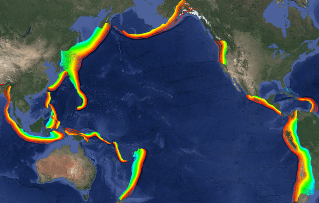
Figure 1. A plot of depth contours of subduction zones within major plate boundaries
In general, five classes of earthquakes are associated with a subduction zone. They are differentiated by their locations within the subduction zone and mechanisms. Figure 2 shows a schematic diagram for four classes.
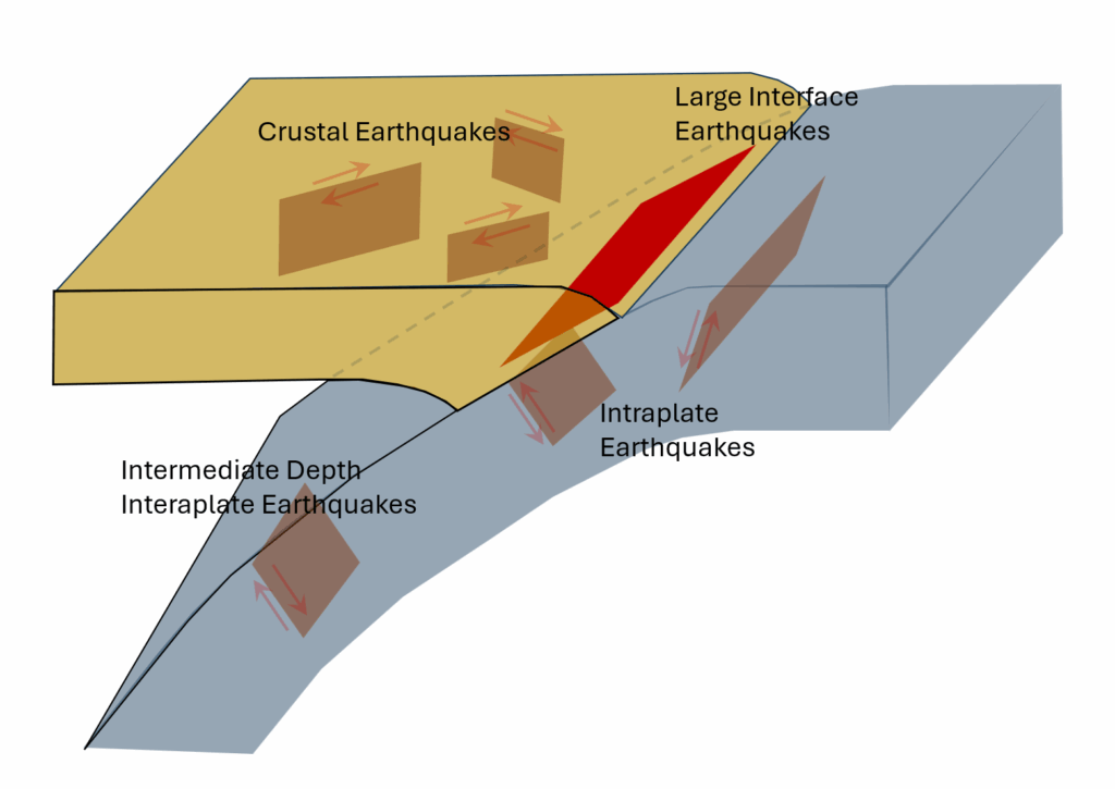
Figure 2. Schematic diagram of a typical subduction zone and the observed different types of earthquakes
Class 1 earthquakes occur within the oceanic plate before entering the subduction zone. Class 2 earthquakes occur within the overriding plate due to the compressional forces exerted by the subducting plate. Class 3 earthquakes are significant thrust events that result directly from the underthrusting of the subducting plate. Class 4 earthquakes occur within the upper part of the subducting plate as a result of the plate’s interaction with the upper mantle. They are known as “Wadati-Benioff zone” earthquakes, after the two scientists who worked on the subject. The mechanisms of class 4 earthquakes depend upon the nature of stress distribution within the subducting plate. Some have normal faulting mechanisms, while others have thrust faulting mechanisms. Class 5 earthquakes are typically related to volcanic activity.
Most earthquakes in subduction zones occur within the top 200 km. However, there are also earthquake activities within the bottom 500 to 700 km. The deepest earthquakes in the world occur in subduction zones. The maximum depth of about 650 km for earthquakes coincides with one of the major velocity discontinuities in the mantle at a depth of approximately 660 km. Seismologists believe that the exact mechanisms responsible for the velocity discontinuity in the mantle are also responsible for creating deep earthquakes.
A typical subduction zone is marked by its trench and volcanic island arc. The trench signifies the beginning of the zone where the oceanic plate begins to subduct beneath the overriding plate. The volcanic islands are the surface manifestations of the oceanic plate’s interaction with hot mantle materials at depth. As the oceanic plate sinks into the mantle, it interacts with hot mantle materials and, at some depth, around 100 km, causes the andesitic magma to form. The magma rises to the surface to create the volcanic island arc. The likely sources of the andesitic magma are the asthenosphere and/or the descending oceanic plate at depth, where materials are partially melted. As the oceanic plate sinks into the mantle, the oceanic crust loses its water content. It is argued that the formation of the andesitic magma in the asthenosphere is initiated by the dewatering of the oceanic crust.
Different plate boundaries could initiate the formation of subduction zones. The following is a brief summary of the causative plate convergences:
- Oceanic Plates Converge: An example of this type of subduction zone is the subduction of the Pacific plate under the western Aleutian Islands
- Ocean-Continent Plate Convergence: Examples are the subduction of the Nazca plate under the South American plate, the subduction of the Pacific plate under the North American plate (the Cascadia subduction zone), the subduction of the Pacific plate under the Okhotsk plate (Japan subduction zone that caused the Tohoku 2011 earthquake), and the subduction of the Philippine Sea plate under the Eurasian plate (the Nankai subduction zone)
- Continent-Continent Plate Convergence: The collision of two continents creates a very complex and broad zone of deformation. These types of collisions do not create subduction zones because continental lithosphere can not sink into the mantle as it is composed of lower-density materials compared with the upper mantle. The collision of India and Asia is the best example. Other examples are the Zagros thrust system in Iran and the Alpine arc in eastern Europe. The Appalachian and Ural mountains are the sites of ancient continental collisions.
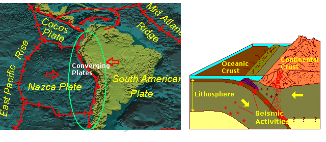
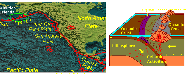
Figure 3. Plots of the South America and North America subduction zones